4. Bird, P., and M. N. Toksöz (1977) Strong attenuation of Rayleigh waves in Tibet, Nature, 266 (5598), 161-163.
The Tibetan Plateau, which has an average elevation of 5.0 km over 7´ 105 km2, is the largest topographic mass above sea- level on the Earth. Because it is covered with Cretaceous limestones1 its uplift must be Tertiary, and is probably related to the Himalayan continental collision. There is considerable debate concerning its present structure and mode of formation. Various authors have theorized that Tibet was uplifted by under- thrusting of a second crustal layer2-6; by horizontal compression and thickening7-9, or by low-density material in the mantle10. All that is known with certainty is that it is isostatically compensated11, and covered with widespread Neogene calc-alkaline volcanic rocksl2. The study of Rayleigh wave attenuation reported here indicates that the lowermost part of the crust is partially molten, and that uplift has been due to horizontal compression.
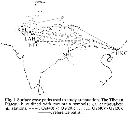
Because of its size, uniformity and difficult access, Tibet is most easily studied using seismic surface waves. Rayleigh waves have the advantage that they are not confused with Love waves even if horizontal refraction causes the waves to arrive from an unknown direction. Because there are no long-period stations north of Tibet, however, the attenuation cannot be measured by using two stations on one ray path. Instead, we have compared Tibetan paths with other reference paths that do not cross the plateau (Fig. 1).
By normalizing the wave spectra at short periods, the azimuthal factor in the source spectrum can be cancelled approximately, and the spectral differences at longer periods can be ascribed to attenuation or scattering. We chose a period of 20 s for normalization, because it is the average spectral peak on the seven reference seismograms. This method gives only a minimum value for attenuation, but records from the nuclear explosion of October 14, 1970 at Lop Nor give similar results without any normalization.
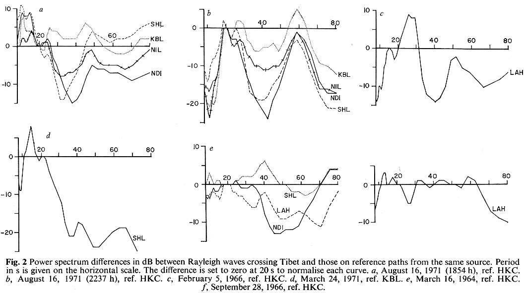
Data from six earthquakes (yielding 14 Tibetan paths) are shown in Fig. 2.
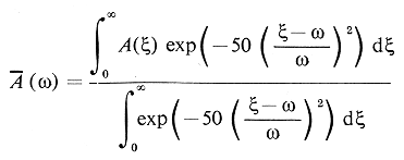
They were obtained by digitizing the long- period vertical records from WWSSN stations at Kabul, Nilore, Lahore, New Delhi, Shillong and Hong Kong. Before differencing, the raw spectra A(w ) were smoothed by the operation:
On 11 of the 14 paths across Tibet, a large reduction in the amplitude of long period (40-50 s) Rayleigh waves is evident. This cannot be due to differences in the instruments (they are identical) or in the source spectrum or path length. They must result from different velocity structures under the stations, scattering or attenuation in Tibet.
The effect of the first is probably minimal, because all stations except Kabul are on stable continental crust of about 40-km thickness13,14. Selective reflection of long periods at the boundaries of Tibet is probably more important. The plateau is, however, bounded by mountain ranges (Himalayas and Kun Lun) in which the crustal thickness change is spread out over more than one wavelength. For such dipping interface problems, it has been found that reflection of Love surface waves is very srnall15, so we do not believe that this effect accounts for the large spectral differences. These have been interpreted as the result of attenuation, so that:
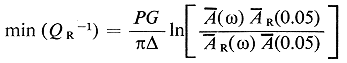
where QR is the Rayleigh elastic quality factor, P is period, G group velocity, D the path length, and AR(w ) the spectrum on the reference path.
The minimum attenuation obtained (Fig. 3) has a peak at 50-s period.
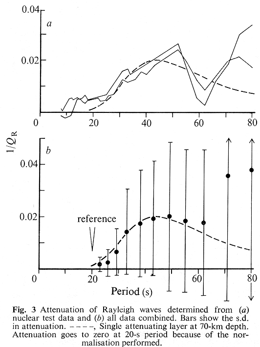
The half-width of the peak is a factor of 2.8 in frequency, which is too narrow to be produced by frequency dependence of a geologically complex medium with various relaxation times, but is more likely to result from an increase of attenuation with depth, so that longer-period waves are more strongly affected. Assuming also that there are no purely dilatational dissipations, we can find the depth to the center of the attenuating layer. Using an Earth velocity model compatible with observations on the group velocities of Rayleigh waves and the equations for a horizontally-layered Earth16, we find that the best-fitting single attenuating layer would be centered at 70 km below the surface. Its 'attenuation thickness' (ratio of layer thickness to Q-1 for shear waves) is 2 km, that is, if the layer is 10 km thick, it has a Q of 5. Such extremely low values of Q are only found in two-phase (partially melted) rocks at such high pressures. There is, also, a suggestion of a second, deeper attenuating layer in the data (Fig. 3), which is not discussed here because it is so poorly resolved.
The geological significance of the inferred partially-molten layer depends on whether it is in the crust or the mantle. From the size of the gravity anomaly11 we can estimate that the crust is between 55 km thick (if the mantle is as hot and light as it is beneath mid-ocean ridges) and 70 km thick (assuming a normal mantle17). Either of these thicknesses is compatible with the group velocity data (Fig. 4) because the lower crustal shear velocity is unknown.
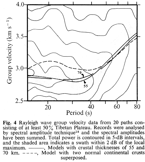
The velocity required in the 70-km model (3.8 km s-1) is more plausible, however, than the very low velocity required in the 55-km model (3.5 km s-1). Also, the volcanics at the surface are clearly of crustal origin8, and it is natural to associate the attenuating layer with their source region.
We conclude that Tibet has a crust of about 70-km thickness, of which the lowermost part is partially molten. The inferred high temperature of the Moho is inconsistent with the crustal-underthrusting model for the formation of Tibet9. ft is suggested that the high temperatures may predate the Himalayan continental collision, and that they may have been responsible for extensive horizontal compression in Tibet after that collision, thus explaining the anomalously thick crust. At present, Tibet overlies an asthenosphere which extends into the lower crust, precluding any long term mechanical strength. This weakness at shallow depths is responsible for the uniformity of Tibetan elevations over wide areas in the center of an orogenic zone.
Peter Bird, Department of Earth and Space Sciences, University of California, Los Angleles, California
M. Nafi Toksöz, Department of Earth and Planetary Sciences, Massachusetts Institute of Technology, Cambridge, Massachusetts
Revised 22 November 1976; accepted 4 January 1977.
1
Hennig, A. Southern Tibet: Discoveries in Former Times Compared with My Own Researches in 1906-1908, 5 (1915).2
Argand, E. C. R. Thirteenth Int. Geol. Congr. 1, part 5, 171-372 (1924).3
Carey, S. W. Proc. R. Soc. Tasmania 89, 255-288 (1955).4
Holmes, A. Principles of Physical Geology (Nelson, London, 1965).5
Powell, C. M. & Conaghan, P. J. Earth Planet. Sci. Lett. 20, 1-12 (1973).6
Powell, C. M. & Conaghan, P. J. Geol. 3, 727-731 (1975).7
Dewey, J. F. & Bird, J. M. J. Geophys. Res. 75, 2625-2647 (1970).8
Dewey, J. F. & Burke, K. C. A. J. Geol. 81, 683-692 (1973).9
Toksöz, M. N. & Bird, P. Tectonophysics 41, 183-191.10
Molnar, P. & Tapponnier, P. Science 189, 419-426 (1975).11
Ambolt, N. Reports from the Scientific Expedition to the N. W. Provinces of China under the Leadership of Dr. Sven Hedin, 2, (1948).12
Kidd, W. S. F. EOS Trans. Am. Geophys. Un. 56, 453 (1975).13
Tandon, A. N. & Chaudhury, H. M. Ind. J. Met. Geophys. 15, 467-474 (1964).14
Tung, J. P. & Teng, T. Univ. S. Cal. Geophys. Lab. Technique Rep., no. 74-2 (Los Angeles, 1974).15
Boore, D. M. J. Geophys. Res. 75, 1512-1527 (1970).16
Lee, W. B. & Solomon, S. C., Geophys. J. R. Astr. Soc. 43, 41-71 (1975).17
Woollard, G. P. J. Geophys. Res. 64, 1521-1544 (1959).18
Dziewonski, A., Bloch, S. & Landisman, M. Bull. Seism. Soc. Am. 59, 427-444 (1969).P.S.
At the time this was written, opinion was polarized between those who thought Tibet is entirely supported by underthrust Indian crust and those who thought it is entirely supported by thickening of indigenous Eurasian crust. This study ruled out the former model by showing that at least some of the Tibetan lower crust is partially molten. However, we were probably wrong to immediately jump to the latter model. Current opinion is that the southern part of Tibet is supported by underthrust Indian crust, while the northern part is supported by thickening of indigenous Eurasian crust. If so, the attenuation we observed probably occurs in the northern part. P. Bird, 2001.08.30