40. Bird, P. (1998b) Kinematic history of the Laramide orogeny in latitudes 35° -49° N, western United States, Tectonics, 17, 780-801.
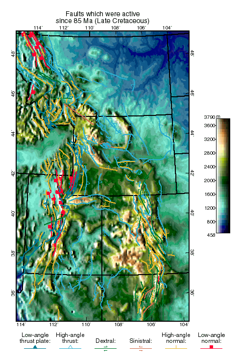
Abstract. The kinematic history of the Rocky Mountain foreland and adjacent areas is computed back to 85 Ma, using virtually all the structural, paleomagnetic, and stress data in the literature. A continuous velocity field is fit to the data in each time step by weighted least squares, and this velocity is integrated back through time. As proposed by Hamilton [1981], the net movement of the Colorado Plateau was a clockwise rotation about a pole in northern Texas; but the rotation was less (3° ) than some have inferred from paleomagnetism. The Laramide orogeny occurred during 75-35 Ma, with peak Colorado Plateau velocities of 1.5 mm yr-1 during 60-55 Ma. The mean azimuth of foreland velocity and mean direction of foreland shortening was stable at 40° for most of the orogeny, increasing to 55° in 50-40 Ma; the counterclockwise rotation of shortening directions proposed by some previous authors is incorrect. Comparing the computed histories of foreland flow speed and direction with the known motions of the Kula and Farallon plates confirms that the Laramide orogeny had a different mechanism from the early Sevier orogeny: it was driven by basal traction during an interval of horizontal subduction, not by edge forces due to coastal subduction or the spreading of the western cordillera or by accretion of terranes to the coast. Tentatively, a minor clockwise rotation of shortening directions at 50 Ma may record the passage of an active Kula-Farallon transform within the subducted slab.

Fault slip-rate movie (363 KB animated .GIF)
Velocity movie (163 KB animated .GIF)
Strain movie (202 KB animated .GIF)
Rotation movie (175 KB animated .GIF)

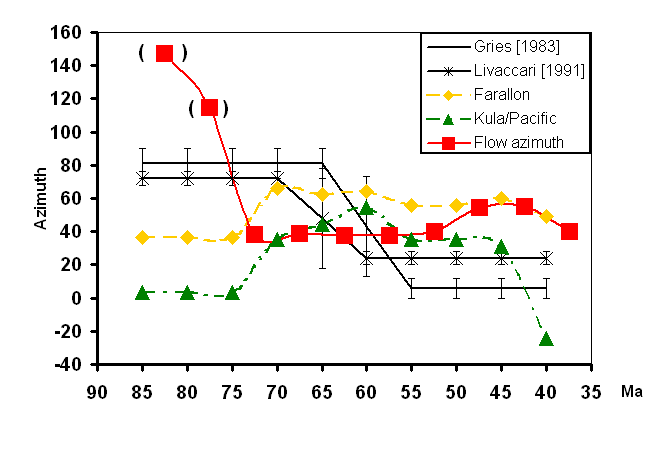
Figure 7. Computed history of the mean azimuth of crustal flow in the Rocky Mountain Foreland and Colorado Plateau (squares), compared to the azimuth histories expected for possible causes. (Crustal flow azimuths are in parentheses until 75 Ma because velocities are very low and these azimuths are probably not reliable.) Curves labeled "Farallon" and "Kula/Pacific" are the azimuths of the velocities of those plates with respect to stable North America at (38° N, 109° W), according to stage poles from Engebretson et al. [1985] Curve labeled "Gries [1983]" shows the inferred history of shortening direction that she attributed to changes in the direction of the absolute velocity of North America. Curve labeled "Livaccari [1991]" shows the inferred history of shortening direction that he attributed to the rise and fall of segments of the western cordillera. No model is satisfactory for all times. Probably the shortening direction was controlled by slip partitioning and slumping of the cordillera before 75 Ma (early Sevier orogeny), but then controlled by coupling to one or both subducted oceanic plates during 75-35 Ma (Laramide orogeny). There is a suggestion that azimuth was controlled by the Kula plate before 50 Ma, and by the Farallon plate after 50 Ma.

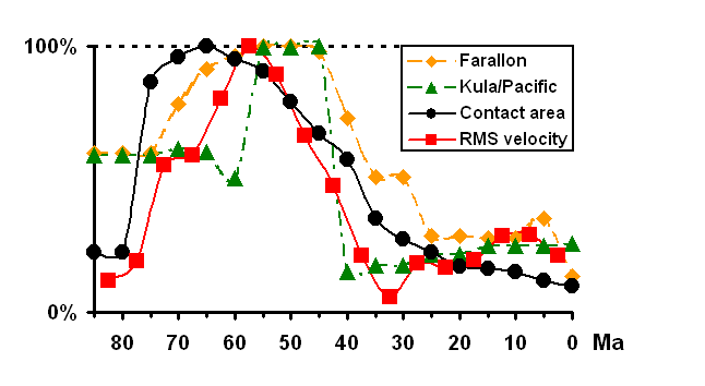
Figure 8. Computed history of the RMS velocity of crustal flow in the Rocky Mountain Foreland and Colorado Plateau (squares), compared to the histories of the magnitudes of possible causes. All curves are normalized to a maximum of 100%. The maximum of RMS velocity was 1.06 mm/a. Curves labeled "Farallon" and "Kula/Pacific" are the velocity histories of those plates with respect to eastern North America; their maxima were 155 and 190 mm/a, respectively. Curve labeled "contact area" is the inferred area of contact between North America and subducted oceanic slab(s), in the latitude range of the United States, with maximum 1.85´ 106 km2, according to Fig. 31 of Bird [1992] which was derived from volcanic-arc positions mapped by Dickinson and Snyder [1978] and slab window areas from Dickinson and Snyder [1979]. The area of contact is the best predictor of the rate of Laramide deformation, especially if they were linked by a power-law relationship..

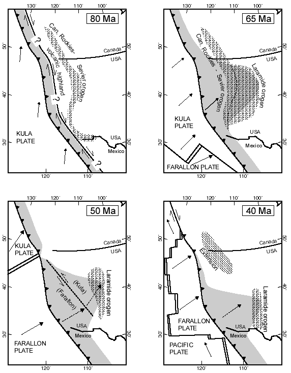
Figure 9. Proposed history of plate configurations based on this study, on plate reconstructions of Engebretson et al. [1985], and on volcanic arc fronts from Dickinson and Snyder [1978] and Urrutia-Fucugauchi [1986]. Shading shows the forearc area of contact between the base of North America and the tops of subducting slabs. Diagonal pattern shows regions of orogeny or extension. At 80 Ma, oblique subduction of the Kula plate caused partitioned deformation: coastal terranes moved North, while the volcanic highland transmitted only Eastward pressure to the Canadian Rocky Mountains and Sevier orogen. By 65 Ma, horizontal subduction under a huge area drove the Laramide orogeny (and the continuing Canadian Rocky Mountains-Sevier orogeny). About 50 Ma, a subducted Kula/Farallon transform boundary may have passed under the forearc, changing the direction of basal tractions. The last stage of the Laramide orogeny, around 40 Ma, was driven by horizontal subduction of the Farallon slab in the southwestern USA and northwest Mexico.
Appendix A: ALGORITHM for program Restore (21-page, 344 KB .pdf file)
Appendix B files are still available, although the URL has changed from that originally published in the Tectonics paper.