![]()
![]()
![]()
![]()
![]()
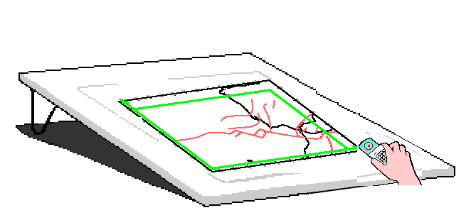
Step 3: Digitise
Most of my programs require the locations of fault traces, which can be digitized from a geologic (or tectonic) map. It is also useful to digitize coastlines, state lines, and national boundaries, just to provide user-friendly location references in maps and figures that you will produce later. If you digitize selected parallels and meridians as well, this will make it possible to check your work in a later step (#5 of this guide). The modern technical term for any string-of-connected-points is "polyline," and all of these 3 classes of data can be considered as collections of polylines.
I can suggest two possible ways to digitize:
1. Modern method with modern hardware and software.
Purchase digitizing software (suitable for your present computer and its
operating system) from a company like ESRI or Golden Software. Personally, I
purchased application Didger5 from Golden Software. This user-friendly
application (which echoes your work with an on-screep map) expects to connect
to the digitizer through the "WinTab API", which is an Application
Programming Interface specification that is supported by most modern digitizing
tablets. My hardware is a Calcomp Drawing Board VI 36" x 24"
digitizing pad, which connects to your computer through either a USB cable or
an RS-232 serial cable. The USB connection is the modern, preferred connection,
and Calcomp supports it by providing a free device-driver program TabletWorks
that also supports the WinTab API. Whatever package you choose *MUST* be able
to Export your polylines as an "ESRI Shapefile (*.shp)" containing
the polylines, and a related "dBase file (*.dbf)" containing the
line-labels and related data. Then you can run my simple conversion utility SHP_toFrom_xyDIG to convert these files to
my .dig file format. An overview of digitizing
with Didger5, and then converting the Exported shapefile & dBase
file, is in this
white-paper.
2. Older method with old hardware and software.
If you still have access to an older Windows computer which runs Windows XP or
Windows NT, and if it is a desktop computer with an RS-232 serial (COM) port
(or a free expansion slot for a card containing a serial port), you can run my
old program Digitise (which was
written in Microsoft Basic and compiled for the DOS operating system). It has
many settings allowing you to obtain digitized (x, y) pairs of numbers
as ASCII character strings (in base 10), and convert them from
digitizer-hardware units (e.g., units of 0.001") to real-world
dimensions in meters, according to the scale of the map you are digitizing.
This program outputs digitized polylines (or points) in my long-standing .dig file format
Regardless of method, remember that you are digitising with the Cartesian (x, y) coordinates that you marked on your map in the previous step, not with parallels of latitude and meridians of longitude. I suggest creating 3 separate .dig files: one for the fault traces; one for the coastlines and/or political boundaries; and one for a representative set of parallels and meridians. I also suggest that you include "_xy" in the name of each file, to distinguish it from the (longitude, latitude)-type .dig files that will be created in the next step.