![]()
![]()
![]()
![]()
![]()
Step 3: Draw a map of numbered fault traces on tracing paper
Get a piece of tracing paper as large as your neotectonic basemap, lay it on top, and tape it down to prevent relative movement. Place this pair of maps on a light-table, if available.
Copy your x and y Cartesian axes (from Step 2) onto this piece of tracing paper.
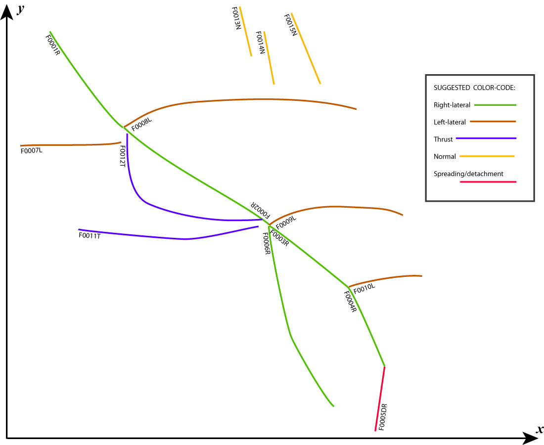
Copy all active (and potentially-active) fault traces from the neotectonic map. I suggest color-coding the traces according to their sense of offset, as indicated in the graphic below. If you use this color-code consistently, then fault-trace maps produced by my mapping program NeoKineMap (in later steps) will have the same color-coding, preventing confusion. I like to draw the traces with COL-ERASE brand pencils, because they are erasable.
Each trace must be labelled with a unique index number, using format “FnnnnV” or sometimes format “FnnnnVW”. The initial “F” serves two purposes: (1) It prevents you from misreading an ambiguous trace index like “0810” upside-down as “0180”. (2) When the trace is digitized (in later steps) into .dig format, the “F” will help to identify the fault-trace-index label as a text line, not as the beginning of a pair of (x, y) Cartesian coordinates.
The fault-trace index-number must have 4 digits; all my programs expect 4-digit fault-trace numbers. Use leading zeros before small integers, as in “F0001R”.
The trailing capital letter “V” (or pair of letters “VW”) gives the dominant sense(s) of neotectonic offset, using codes: R = Right-lateral, L = Left-lateral, T = Thrust, N = Normal, and D = Detachment (or spreading center). You can combine two letters for oblique slip, as in the label below “F0005DR” which marks a fault that has both a Detachment/spreading component and also a Right-lateral component. The dominant (larger) component should be written first.
The text label “FnnnnV” is written parallel to the trace, starting at one end. When the trace is digitized (in the next step), digitizing will start here. Vertically-dipping, strike-slip faults can have their labels placed at either end. HOWEVER, non-vertically-dipping faults MUST have the label on the side OPPOSITE to any dip-tick markers. That is, when the fault trace is digitized, its dip must be to the LEFT when looking along the trace in the digitizing direction. For example, in the map below, F0011T and F0012T are both dipping North. Normal faults F0013N, F0014N, and F0015N are all dipping NE.
It is a good idea to record the name of the fault at the same time that you copy its trace. If more than one name is commonly used for a fault, then record them both (“Hayward-Calaveras dextral fault, CA”); this will help in later steps when you search for data on offset features! When no fault name is known, label the fault by its offset-sense and location, as in, “normal fault, 105W, 37-36N, CA”. If there is room, this fault name could be written directly onto the map. Otherwise, you should keep a note-pad nearby and record, “F0002R San Andreas (Mojave segment) dextral fault, CA” and so on. The note-pad method is best, as it helps to prevent accidentally re-using any fault-trace index number (as when you resume work on the map after a long time away)!
Does your study area include an active monocline or other “forced fold”? If so, try to include the sub-surface trace of the active blind thrust fault as a trace of offset type “T”. The blind thrust fault is usually beneath the monocline, marked at the surface by distributed brittle rock deformation and steep dips of sedimentary beds (if any). (The other limb of a monocline-related antiform is usually gentle, and lies over a “fault-bend fold” caused by a change of dip, from flat to ramp, in the active thrust fault. Do not include both limbs of a monocline-related antiform on your fault-trace map.)
Detachment faults that have created metamorphic core complexes sometimes present a choice of several fault traces, of slightly different ages. The trace of the initial breakaway fault can be used if nothing else is clear. However, for neotectonic modeling purposes we would prefer to use the most recent trace, which may run along the margin of an adjacent sedimentary basin (with “growth strata,” whose dips increase with age downward in the section).
If there is a sea-floor spreading center active in your study area, then map its central magnetic anomaly as a red trace of offset type “D”. (In this case, the sense of dip will be arbitrary, and unimportant.)
![]()
![]()
![]()
![]()
![]()