45. Bird, P. (2002) Stress-direction history of the western United States and Mexico since 85 Ma, Tectonics, 21(3), doi:10.1029/2001TC001319.
Abstract. 369 paleostress direction indicators (sets of dikes, veins,
or fault slip vectors) are collected from previous compilations and the
geologic literature. Like contemporary data, these stress directions show great
variability, even over short distances. Therefore, statistical methods are
helpful in deciding which apparent variations in space or in time are
significant. First, the interpolation technique of Bird and Li [1996] is used to
interpolate stress directions to a grid of evenly-spaced points in each of
seventeen 5-m.y. time steps since 85 Ma. Then, a t-test is used
to search for stress direction changes between pairs of time windows whose
sense can be determined with some minimum confidence. Available data cannot
resolve local stress provinces, and only the broadest changes affecting
country-sized regions are reasonably certain. During 85-50 Ma, the most
compressive horizontal stress azimuth ![]() was
fairly constant at about 68º (United States) to 75º (Mexico). During 50-35 Ma,
both counterclockwise stress changes (in the Pacific Northwest) and clockwise
stress changes (from Nevada to New Mexico) are seen, but only locally and with
about 50%-confidence. A major stress-azimuth change by ~90º occurred at 33±2 Ma
in Mexico and at 30±2 Ma in the western United States. This was probably an
interchange between
was
fairly constant at about 68º (United States) to 75º (Mexico). During 50-35 Ma,
both counterclockwise stress changes (in the Pacific Northwest) and clockwise
stress changes (from Nevada to New Mexico) are seen, but only locally and with
about 50%-confidence. A major stress-azimuth change by ~90º occurred at 33±2 Ma
in Mexico and at 30±2 Ma in the western United States. This was probably an
interchange between ![]() and
and
![]() caused
by a decrease in horizontal compression and/or an increase in vertical
compression. The most likely cause was the roll-back of horizontally-subducting
Farallon slab from under the southwestern United States and northwest Mexico,
which was rapid during 35-25 Ma. After this transition, a clockwise rotation of
principal stress axes by 36-48º occurred more gradually since 22 Ma, affecting
the region between latitudes 28ºN and 41ºN. This occurred as the lengthening
Pacific/North America transform boundary gradually added dextral shear on
northwest-striking planes to the previous stress field of SW-NE extension.
caused
by a decrease in horizontal compression and/or an increase in vertical
compression. The most likely cause was the roll-back of horizontally-subducting
Farallon slab from under the southwestern United States and northwest Mexico,
which was rapid during 35-25 Ma. After this transition, a clockwise rotation of
principal stress axes by 36-48º occurred more gradually since 22 Ma, affecting
the region between latitudes 28ºN and 41ºN. This occurred as the lengthening
Pacific/North America transform boundary gradually added dextral shear on
northwest-striking planes to the previous stress field of SW-NE extension.
Entire paper as a 12-page black/white .pdf file (2.6 MB)
The paleostress direction data base (3 small text files, via FTP)
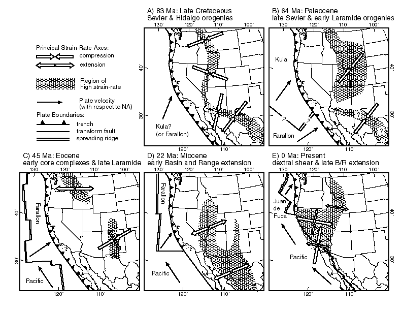
Figure 1. Schematic and qualitative tectonic history, based on Engebretson et al. [1985], de Cserna [1989], Axen et al. [1993], and Bird [1998]. No palinspastic restoration is attempted (except in the Pacific basin). Regions of highest strain-rate at each epoch are shown with shading. Only the strain-rate axes in the northern part of (B) and the southern part of (C) result from formal computations [Bird, 1998]; other axes are drawn perpendicular to the mean trend of dip-slip faults active at that time. Distribution of high strain-rates in (E) is based primarily on historical seismicity.
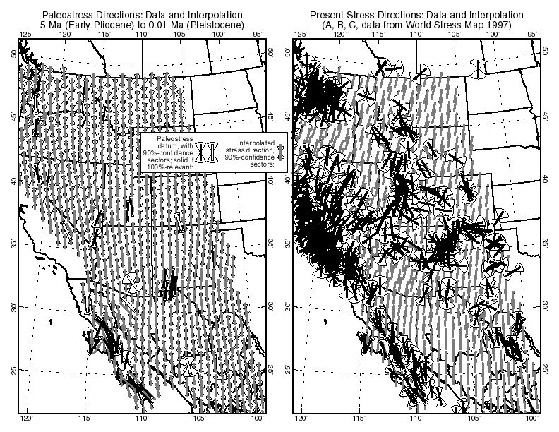
Figure 2. Comparison of 39
paleostress direction data [left, from the most recent 5-m.y. time window] with
706 quality "A", "B", or "C" contemporary stress
direction data from the World Stress Map [right, from Mueller et al.,
1997]. Each data set has been interpolated with the same algorithm (Appendix
B). All symbols show the azimuth of ![]() ,
the most compressive horizontal principal stress direction. Because stress
direction data are noisy, statistical interpolation by the method of Bird and Li [1996] gives only
limited weight to the nearest data, and results in very smooth fields of
interpolated directions (gray bars). An alternative view is that most
high-quality data are basically correct, and that the stress-direction field is
separated into small provinces by sharp transitions [Zoback and Zoback,
1980]. The difference in interpolated
,
the most compressive horizontal principal stress direction. Because stress
direction data are noisy, statistical interpolation by the method of Bird and Li [1996] gives only
limited weight to the nearest data, and results in very smooth fields of
interpolated directions (gray bars). An alternative view is that most
high-quality data are basically correct, and that the stress-direction field is
separated into small provinces by sharp transitions [Zoback and Zoback,
1980]. The difference in interpolated ![]() azimuths
from the United States portion of the left map to the right map is about 12º, which
could be an artifact of the limited amount of paleostress data. (The difference
would be within the 90%-confidence limits shown.) However, this paper argues
that the effect is real, because it is the continuation of a gradual clockwise
rotation of stress directions that began about 22 Ma.
azimuths
from the United States portion of the left map to the right map is about 12º, which
could be an artifact of the limited amount of paleostress data. (The difference
would be within the 90%-confidence limits shown.) However, this paper argues
that the effect is real, because it is the continuation of a gradual clockwise
rotation of stress directions that began about 22 Ma.
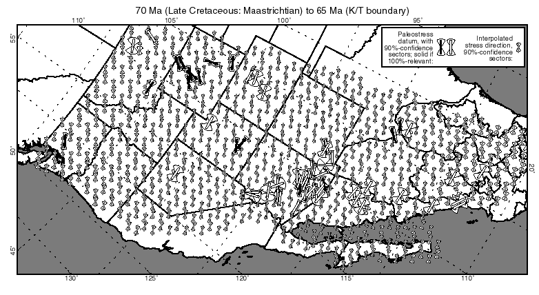
Figure 3. Geologic data on the
direction of the most-compressive horizontal principal stress ![]() (solid
or open-box bars) and interpolated
(solid
or open-box bars) and interpolated ![]() directions
(gray bars) during the time step 70-65 Ma (Late Cretaceous: Maastrichtian).
Data are plotted at present coordinates, without palinspastic restoration.
Oblique Mercator projection, which is conformal. Open-box symbols indicate data
which have only fractional relevance to this time step. Note that data in
Nevada, Utah, and Colorado could be interpreted as establishing a different
(E-W) direction. However, most of these data have fractional relevance and
large uncertainties.
directions
(gray bars) during the time step 70-65 Ma (Late Cretaceous: Maastrichtian).
Data are plotted at present coordinates, without palinspastic restoration.
Oblique Mercator projection, which is conformal. Open-box symbols indicate data
which have only fractional relevance to this time step. Note that data in
Nevada, Utah, and Colorado could be interpreted as establishing a different
(E-W) direction. However, most of these data have fractional relevance and
large uncertainties.
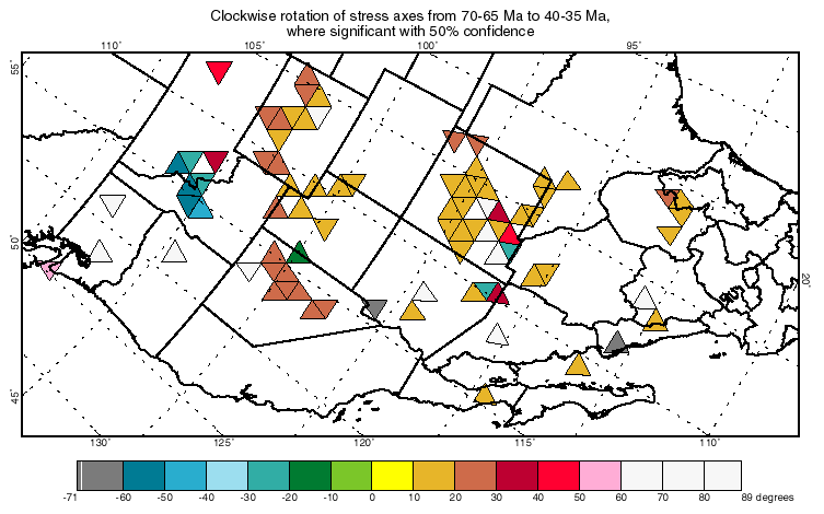
Figure 4. Stress change map,
comparing "early Laramide" time step 70-65 Ma (Late Cretaceous:
Maastrichtian) with "late Laramide" time step 40-35 Ma (Middle-Late
Eocene). Triangles merely show the geographic region associated with each
interpolation grid point. Color of triangle indicates the amount of rotation of
![]() from
the earlier time to the later. Triangles are only plotted around grid points
where rotation is significant with 50% or greater confidence, according to a t-test.
The most common rotations are 10-30° clockwise,
in scattered areas such as east-central Nevada, Wyoming, and New Mexico.
Counterclockwise rotation is seen mainly in the areas of the Eocene dike swarm
of Hyndman et al. [1988] in Idaho-Montana. Oblique Mercator projection,
showing present state lines without palinspastic restoration.
from
the earlier time to the later. Triangles are only plotted around grid points
where rotation is significant with 50% or greater confidence, according to a t-test.
The most common rotations are 10-30° clockwise,
in scattered areas such as east-central Nevada, Wyoming, and New Mexico.
Counterclockwise rotation is seen mainly in the areas of the Eocene dike swarm
of Hyndman et al. [1988] in Idaho-Montana. Oblique Mercator projection,
showing present state lines without palinspastic restoration.
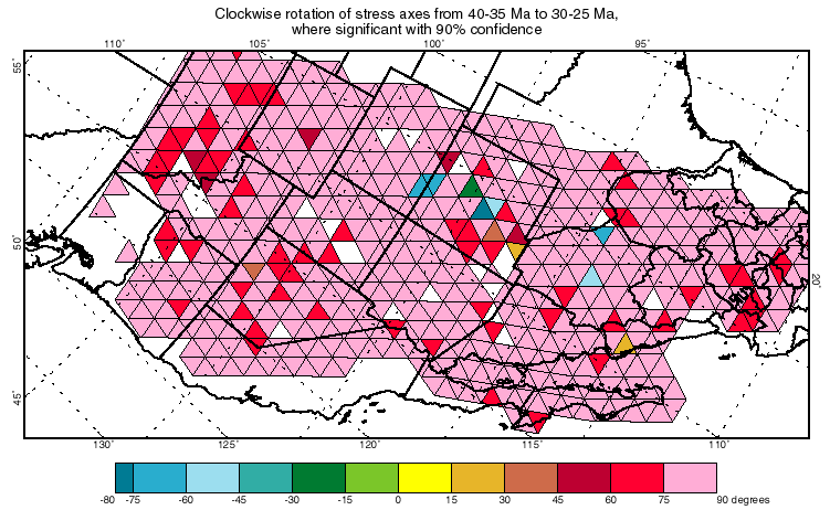
Figure 5. Stress change map,
comparing the 40-35 Ma (Middle-Late Eocene) time step with the 30-25 Ma
(mid-Oligocene) time step. Conventions as in Figure 4, except that here all
rotations shown are significant with 90%-confidence. A dramatic change in ![]() azimuth
by nearly 90º (the greatest possible change) has affected the whole region.
This is interpreted as an interchange of the most-compressive and
least-compressive stress axes.
azimuth
by nearly 90º (the greatest possible change) has affected the whole region.
This is interpreted as an interchange of the most-compressive and
least-compressive stress axes.
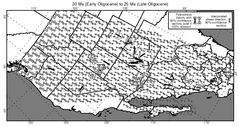
Figure 6. Geologic data on the
direction of the most-compressive horizontal principal stress ![]() (solid
or open-box bars) and interpolated
(solid
or open-box bars) and interpolated ![]() directions
(gray bars) during the time step 30-25 Ma (mid-Oligocene). Conventions as in
Figures 2 and 3.
directions
(gray bars) during the time step 30-25 Ma (mid-Oligocene). Conventions as in
Figures 2 and 3.
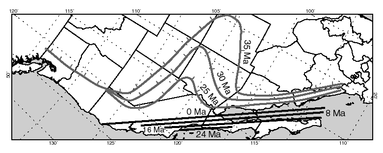
Figure 7. Possible causes for the two greatest stress reorientations found in this study. Grey lines labeled 35, 30, and 25 Ma mark the western limits of arc volcanism at each of those times, according to Dickinson and Snyder [1978] and Urrutia-Fucugauchi [1986]. Lands to the southwest of these lines were underlain by oceanic lithosphere of the Farallon plate, subducting horizontally to the northeast. The progressive loss of contact with the Farallon plate decreased horizontal coupling to North America and decreased the northeast-ward compression, while simultaneously causing uplift and increased vertical compression. Solid lines labeled 24, 16, 8, and 0 Ma show the latitudinal extent (but not the correct longitude) of the Pacific/North America transform margin (ref. Figure 1 D-E), according to Engebretson et al. [1985]. Increasing transform length probably caused increased transmission of northwestward tractions from the Pacific plate to North America. Superposed on the pre-existing NE-SW extensional stress field, this caused a clockwise rotation of principal stress axes.
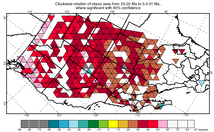
Figure 8. Stress change map,
comparing the 25-20 Ma (Late Oligocene-Early Miocene) time step with the 5-0.01
Ma (Pliocene-Pleistocene) time step. Conventions as in Figure 4, except that
here all rotations shown are significant with 90%-confidence. This reveals the
cumulative effects of a slow clockwise rotation of ![]() .
.

Figure 9. History of
most-compressive horizontal principal stress (![]() )
azimuth at "Four Corners" (37ºN, 109ºW) in the southwestern United
States since 85 Ma. Fine bounding lines show 90%-confidence limits at each time
step. (Smooth curves are drawn through discrete values computed for 5 m.y.
steps, although it was necessary to assume constant azimuth within each time
step in order to do the calculations.) Diamond at (0 Ma, 11º) shows the result
from the contemporary stress field of Figure 2.
)
azimuth at "Four Corners" (37ºN, 109ºW) in the southwestern United
States since 85 Ma. Fine bounding lines show 90%-confidence limits at each time
step. (Smooth curves are drawn through discrete values computed for 5 m.y.
steps, although it was necessary to assume constant azimuth within each time
step in order to do the calculations.) Diamond at (0 Ma, 11º) shows the result
from the contemporary stress field of Figure 2.